Thursday, August 29, 2013

OMA WATERHOLE

30th August, 2013

For the past two weeks we have been camping at Oma Waterhole on the Barcoo River a hundred kilometres south of Ilfracombe. 
Our campsite at Oma Waterhole
It’s a wonderful place to recharge one’s batteries and just get away from it all.  There are other campers here but it’s a long waterhole and our nearest neighbour is over a hundred metres away.  We spend our days relaxing, reading and doing ‘bugger all’.   Wok has been fishing
Wok taking it easy
and is often joined by a stork.
Wok at the waterhole - stork in the background near the shore
 He occasionally catches a yellow belly for dinner.
Yep - that yellowbelly is headed for the frypan
There are quite a few pelicans at the waterhole and whenever Wok catches a fish they fly in to see what is on offer.
Pelicans coming in for a landing
The pelicans are quick to seize any small fish that is undersized and not quick enough to swim away when it is released.
The pelican on the left is making a quick getaway with the fish
They also squabble over fish scraps that Wok discards after filleting his catch.
A minor disagreement about the pecking order at the pelican buffet
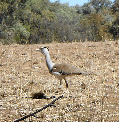
There are lots of other birds at the waterhole – cormorants, water hens, emus, apostle birds, crows, a myriad of small birds and kites.  There is a large kite’s nest in the top of a tree on the far bank but so far we have not seen any fledglings.  One of the more unusual birds is the bustard.
The regal bustard
This rather stately bird just wanders by seemingly oblivious to the rest of the world.  It never seems to be in a hurry and always appears to be calm and dignified.
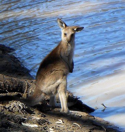
Cattle and goats come for a drink at the waterhole along with kangaroos.  A mother kangaroo and her joey don’t seem too worried by our presence and visit with us each day.
Mother kangaroo and joey
Mother kangaroo and joey join Wok on the shore
The joey is really cute.
Just love the joey's floppy ear
It's hot work trying to keep up with mum
Our friendly stork will probably be sad to see Wok go as it has been getting a few handouts of prawns.
We have no idea if this is a stork but he/she sure has pretty markings
From here it is only a couple of days travelling and we will be back on the Sunshine Coast - time to touch base with doctors etc. before we head off again.  We really have enjoyed our two weeks at Oma Waterhole.  This is the second time we have stayed at the waterhole and it probably won’t be our last.  Who would have thought we would place a muddy waterhole at the top of our ‘places we would like to return to’ list …. !

MOUNT ISA to ILFRACOMBE

8th August, 2013

There we were – hurtling along at an incredible 70 kilometres per hour – making our way through the corrugations towards the main highway leading to Mount Isa – when we rounded a corner and joined a large herd of cattle being mustered along the track. 
Cattle muster
It was a real family affair with Mum, Dad and the kids plus a few stockmen moving the cattle from the outlying paddocks to a corral near the homestead.  It took us quite a while to make our way through the herd and we chatted with the drovers as we went along.  The drovers tried urging the cattle out of the way but they stubbornly refused to budge off the road and kept pace with us for a couple of kilometres.
Joining in with the herd ...
Ahh well!  Life is a little slower out here and there’s something iconic about cattle being mustered in the outback.
After a stopover in Mount Isa to restock, refuel and re-gas we decided to take the road less travelled and headed south to Boulia.  Now we were entering the land of the Min Min Light – a strange light that at night sometimes follows travelers for long distances.  It has been approached but never identified.  There have been many sightings and stories about the Min Min Light over the years and the town of Boulia has kept the legend alive.  Boulia is also home to the ‘Red Stump’ – a sign that there isn’t much further west except the Simpson Desert.

 
As we have no intention of crossing the desert (this time) - we turn east and follow the old Cobb and Co route through a rugged landscape.  Not much vegetation around and although it is supposed to be good beef country we can’t help wondering how the cattle survive.  We free camp overnight and stop beside a lonely grave near the site of the old Min Min Hotel.
Grave at the old Min Min Hotel site

A sign fills in the story behind the grave and the hotel and a stockman’s encounter with the Min Min Light.
 
We continue east and stop at Cawnpore Lookout in the Lilleyvale Hills.
Mitzi and the Van at Cawnpore Lookout
From the lookout we can see the road ahead – stretching eastwards between the rocky outcrops.
The view east from Cawnpore Lookout
Fifty kilometres further on we arrive at Middleton Hotel built in 1876. 

Middleton Hotel
The hotel was one of nine changing stations for Cobb and Co and is the last building left standing on the Winton to Boulia run.

We have only a hundred kilometres left before we arrive at Winton.  We have free camped for three nights in the land of the Min Min Light and apart from the brilliant stars in the Milky Way we didn’t see any signs of the mysterious light.  Perhaps we were fast asleep when it came around …
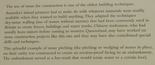
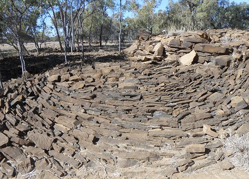
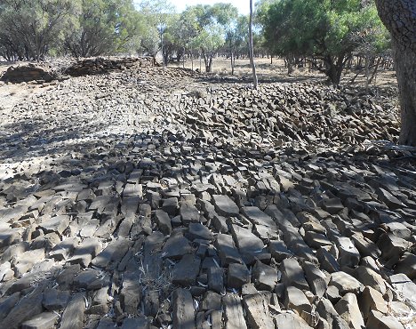
It was time for Mitzi to have her 60,000 kilometre service – so we booked her in at the Mitsubishi  Dealer in Longreach.  We arrived late in the afternoon on the outskirts of Longreach and headed for a free camp area on the Thomson River four kilometres out of town.  Oh My God!  The dusty parking area was brimming over with caravans and campers.  We slotted in at the end of the line and settled down for the night.  There were over a hundred rigs – bigger than most of the caravan parks out this way.  As we were booked in at the dealer for early in the morning we only needed somewhere to sleep and at 7.30am we packed up and headed into town.  We found a good spot not far from the workshop to unhook the van and at 8.15am Mitzi was at the dealers.  The supermarket wasn’t far away so we took the opportunity to restock and by lunchtime Mitzi was all done and we were on our way again.  We’d travelled this road last year and decided to stop at Ilfracombe (30 klms east of Longreach) and stay a couple of nights at the caravan park where we could catch up with some household chores.  While we were there we drove down to the ‘12 Mile’ to have a look at the art of ‘stone pitching’ – a wonderful example of nineteenth century bush craftsmanship.
 

As we wander over the flagstones we are in awe of the work that must have been involved to transport these rocks to the site and then place them into position.
Stone Pitching at the 12 Mile
It is over a hundred years since these rocks were laid and they are still in place.  Amazing!
Stone Pitching at the 12 Mile
Back at the caravan park we were relaxing and watching the world go by when a bevy of emus strolled past.  They wandered through the park and then crossed the road
Emus going for a walk at Ilfracombe
where they diligently inspected the corner of a neglected garden.
Ok Ok - stop pushing!  Everyone will get a chance to have a look ...
You just never know what might pass by out here ….


LAWN HILL GORGE and RIVERSLEIGH FOSSIL SITE

1st August, 2013

We’re on the road again, retracing our steps back to Normanton and then leaving the bitumen and travelling west on unsealed roads.  Thirty five kilometers into our journey we take a short detour to take a look at Burke and Wills’ most northerly camp on their trek north to the gulf – Camp 119.
Wok checks out the blaze on a tree at Camp 119
Trees that were blazed by the two explorers and their two men (King and Grey) still survive.  The creek on which they camped is dry now but when they were here it was summer time and the rivers and creeks were in full flood.  From Camp 119 the explorers attempted to reach the shore of the Gulf of Carpentaria but couldn’t make their way through the swamplands.  To all intents and purposes they had actually reached their goal and the crossing of the continent from South to North was achieved.  Sadly Burke, Wills and Grey perished on the return journey south.  King was taken in by a group of aboriginals and survived to tell the tale.
We continue west and freecamp that night at Leichardt River Falls.
Leichardt River Falls - we are camped on the far bank (top left)
Like many of the waterways up here the river has been reduced to a series of waterholes but large logs have been washed down the river during the wet and are lodged high up on the rocks.  The river must be a spectacular sight in the wet season.  In the morning we arrive at Burketown – the Gulf’s oldest town established in 1865 on the banks of the Albert River 25 klms from the coast.  It’s a popular fishing spot for barramundi and light aircraft enthusiasts surf the ‘Morning Glory’ – an unusual tubular cloud formation that rolls out of the gulf in the early mornings from September to November.   On the southern entry to the town is an artesian bore that was sunk in 1896 and still issues boiling water creating a waterhole for birdlife.
Artesian Bore at Burketown
The bore was to have supplied the town with drinking water but it was later discovered that there were too many minerals in the water which made it unfit for drinking.  In the early days a shower was built near the bore and many a dusty traveler welcomed the refreshing hot shower that was offered free of charge.  From Burketown we head south to Gregory Downs where we had hoped to camp along the Gregory River which is spring fed and flows all year round.  One look was all we needed to know that this was not a good idea.  Every man and his dog seemed to be camped beside the river and a second line of campers were squished into any other space available.  It was so overcrowded that we were literally driving around caravans and tents pitched along the access track.  Dogs were running riot and generators were adding to the mêlée.  We managed to turn around and couldn’t get out fast enough – not our idea of peace and quiet.  We had thought to overnight at the river before making our way to Lawn Hill Gorge but as it was early afternoon we decided to push on and arrived at Adel’s Grove Campground by 4pm.  Adel’s Grove is a 32 hectare freehold property on Lawn Hill Creek and is completely surrounded by the 6,000 square kilometre Lawn Hill Station cattle property which is a Fauna and Flora Reserve.  There are two small campgrounds in Boodjamulla National Park (formerly Lawn Hill National Park) but at this time of year sites are fully booked.  As there are no free camping spots near the National Park the only other option is at Adel’s Grove.  It’s a nice enough camping spot with lots of sites (all unpowered), rooms and pre-erected tents.  Of course when you have no competitor then you can charge whatever you like.  We thought $34 per night for two people on an unpowered site was really being greedy.  We did however want to see Lawn Hill Gorge so we dug deep and booked in for two nights.  In the morning we headed out early and drove the 10 klms to the National Park where we hired a two man canoe and set out to do some exploring.
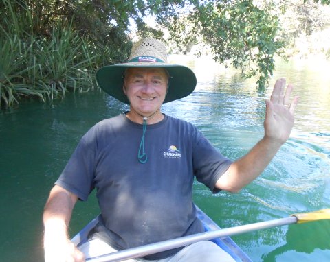
Wok is happy to do the paddling - but we have only just started out
This fascinating gorge system provides a sanctuary for remnants of the ancient rainforest that covered the Gulf Savannah millions of years ago.
Some of the scenery in Lawn Hill Gorge
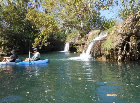
We paddled up Lawn Hill Creek (actually Wok did most of the paddling as he had the double paddle) with lush tropical vegetation crowding the banks.  The water is green and crystal clear and we pass between sixty metre high sandstone cliffs.  There are two gorges at Lawn Hill and at the top end of the lower gorge the water cascades over the rocks from the upper gorge creating mini waterfalls.
Water flows over mini waterfalls from the top gorge to the lower gorge
It is here that we have to beach the canoe and then drag it up a steep slope and along the bank if we want to continue along the upper gorge.
View of the waterfalls between the top gorge and lower gorge
We were in fits of laughter as we tried to get out of the canoe onto the bank.  Old legs cramped up in a canoe do not make for a graceful exit.  Ohh ... if only we were thirty years younger!  We did finally manage to get ashore and dragged the canoe a short way up the bank.  Thankfully a super fit thirty year old guy took pity on us and helped Wok carry the canoe the rest of the way to the top gorge.  The top gorge was equally as spectacular as the lower gorge
Heading up the top gorge at Lawn Hill
and at the top end of the gorge the sandstone cliffs gave way to open woodland.
The upper end of the top gorge at Lawn Hill
Lawn Hill Creek is also spring fed and finally we could go no further.   The water was flowing into the creek from the spring at quite a rate and as we turned the canoe around the current gently carried us back down the creek.
Spring fed water entering the top gorge at Lawn Hill
In this part of the creek there were lots of fish swimming around and they followed our canoe for a short time.
Curious fish in the top gorge at Lawn Hill
We lazily paddled our way back down the upper gorge and Wok managed to haul the canoe from the upper gorge to the lower gorge without any assistance – well done Wok!  As we paddled round the last bend we took one last look back up the gorge.
Lawn Hill Gorge
Yep!  This is certainly a surprising oasis out here in the middle of nowhere! 
After returning the canoe we had a picnic lunch and then took a couple of walks along the trails that overlooked the creek before calling it a day and heading back to camp.  Boy did we appreciate a nice long shower when we got back to camp.  The following morning we packed up and headed south 65 klms to Riversleigh Fossil Site.  The unsealed road was pretty rough in some places but overall Mitzi and the Van handled it well.  Riversleigh Fossil Fields also lie within part of the Boodjamulla National Park and here palaeontologists have discovered fossilized remains of creatures formerly unknown to science, doubling the sum of knowledge of Australia’s prehistoric fauna.  Pale grey limestone, formed in spring-fed lakes and pools encase the fossilized remains of strange animals, birds, reptiles and plants that span 25 million years of Australia’s evolutionary history.  We pull up in the car park and follow a track to the information centre.  We really like the way this information centre blends into the landscape. 
Information Centre at Riversleigh Fossil Site
It’s not until you notice the pipe running up the side of the rock that you realize that this rock is man-made.  The rock is hollow and houses a rest room and an open area which has information on the Riversleigh Fossil Field and a bas-relief of what two of the discovered fossilized animals would have looked like.
Big Birdus and Crocodilius
It also appears that some swallows have found the ceiling of the information centre the perfect place to build their mud nests.
Swallow's mud nests on ceiling of information centre
We follow the circular track up and over the hill, stopping to read the information boards along the way and look at the fossilized remains in the rocks.  The last board tells us of ‘Big Bird’  -  No    not the one in Sesame Street.  This ‘Big Bird’ is a whole other thing.
 
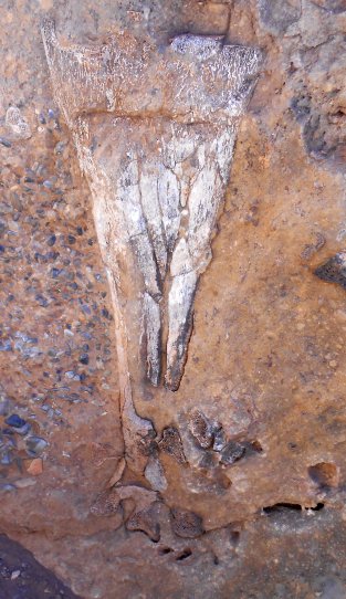
We looked all over the rock beside the board trying to find the leg bone they were describing and finally found it facing the other way.
Fossilised leg bone of 'Big Bird'
We sure wouldn’t want to meet one of these birds walking down the street on a dark night – or on any kind of night come to think of it.  It is hard to imagine this dry, dusty, parched countryside covered in lush green rainforest and teaming with life.  Wonder what it will look like in another 25 million years  …..

Wednesday, August 28, 2013

PORT DOUGLAS to KARUMBA

     15th July, 2013

We’ve spent nearly seven weeks on the Atherton Tablelands and have only ventured to the coast a couple of times.  Before we continue our travels we decide to take a day trip down to Cairns and follow the coastal road to Port Douglas.  The city of Cairns has grown over the years and fields of sugar cane have now been replaced by ever expanding suburbia.  The foreshore has had a facelift and mangrove lined mudflats are now relegated to north and south of the main tourist area.  Many of the tourist coastal towns are starting to look alike – with promenades along the waterfront parklands, one way boulevards and street cafes.  The coastal drive to Port Douglas is still very picturesque with the aqua blue waters lapping against palm fringed beaches.  We make our way to the lookout and are absolutely stunned to discover that the once beautiful view along the coast is being marred by the construction of a building/residence.
Lookout at Port Douglas - View spoiled by ugly construction
We wonder what idiot or idiots in the local council allowed this structure to be built.  For a locality that promotes itself as a tourist venue the loss of this wonderful outlook is unforgiveable.  Ahh well!  Sometimes money speaks louder than words.  At Mossman we are transported back to another time – when life ran at a slower pace and the cane trains ran even slower.
Sugar Cane Train at Mossman
A pleasant drive up the mountains brought us up onto the tablelands and back to our base camp at Walkamin Caravan Park.  A few days later we packed up the rig, waved goodbye to the many friends we had made at the caravan park and hit the road.  We travelled south to Ravenshoe and called in at Millstream Falls
Millstream Falls
 where we met a friendly kookaburra in the parking lot.
Kookaburra at Millstream Falls
We free camped that night at Archer Creek and the next day checked into Bedrock Village Caravan Park at Mount Surprise.  We took a walk across the railway tracks and passed the old cemetery.
Mount Surprise Cemetery
Mount Surprise is a railway town on the old Cairns to Forsayth Railway Line.  It is the centre for gem fossicking with topaz, quartz, garnet and aquamarine to be found.  We stop in at the gem shop and take out a fossicker’s licence.  We plan on heading out to the gem fields for a picnic lunch tomorrow and try our luck.  The following morning we head out to Kalkani Crater which is part of the Undara Volcanic National Park.  Situated on the McBride Volcanic Province, the Undara Volcanic National Park is 40 km east of Mount Surprise with evidence of volcanic activity from 164 craters.  One of the most recent and major eruptions 190,000 years ago produced 23 cubic kilometers of lava, most of which flowed down the western side of the Great Divide.  This flow created a geological phenomenon now known as the Undara Lava Tubes.  The lava tubes wind for over 90 km underground, making them the longest network in the world.  Undara is an aboriginal word for ‘a long way’.  We walk up the side of the Kalkani Crater and around the rim.
View from Kalkani Crater
From the rim we can see the surrounding countryside and the occasional line of green trees and shrubs that mark the location of collapsed lava tubes.  We visited the lava tubes many years ago and they are certainly worth a look see if you haven’t been before.  At that time we had no idea this volcanic crater was here and it is great to get a different perspective on the enormous size of this national park.  We make our way back to Mitzi and drive to O’Brien’s Creek gem fields for a picnic lunch beside a very dry and dusty, rocky water course.  We pick a likely looking spot to find gems (how the hell do we know) and for the next few hours proceed to move an abundant amount of rocks and dirt from one place to another.  We have a sieve to plonk the shovels full of potential gem bearing earth into but all we find is smoky quartz.
Don't think that Wok is really taking this fossicking game seriously
We may be pretty hopeless at gem fossicking but it was fun trying and certainly gave us a good workout.  The whole afternoon wasn’t a dead loss though – we were just about to give up when Wok dug up a ‘burrowing frog’.
A burrowing frog - isn't he cute?
This poor little guy/girl was minding his/her own business and hibernating way down in the earth when along we come, dump him/her in the sieve and shake the living daylights out of it.  Wok rescued the frog from the sieve and after taking its photo dug a nice hole (well we thought it looked nice – the frog seemed to have no opinion either way) then placed the frog in the hole and covered him/her back up.  These ‘burrowing frogs’ are amazing – they hibernate for months and months waiting for the wet season to arrive.  When the rains come and the creeks flow they emerge and breed.  When the wet season is over they burrow back into the earth and the cycle starts all over again.  Nature is truly incredible!  After our trek up and around the volcanic crater in the morning and an afternoon of dusty digging we sure did appreciate the luxury of a good shower back at the campground.  At midday the following day we joined a group of fellow travelers for a ride on the Savannahlander.  This historic rail motor was established in the 1900’s and now operates once a week between Cairns and Forsayth as a tourist attraction.  We are only going to join it for one leg of its journey – between Mount Surprise and Einasleigh.
The Savannahlander
The train gets along at a dignified pace and the driver regales us with the history of the train and the countryside we are travelling through.  As this is a tourist train the driver has no qualms about slowing down or stopping so that the passengers can get that perfect photo.  A stop along this creek crossing caused a bit of a problem when the train didn’t have enough oomph to pull up the slight slope on the other side.
Crossing a creek in the Savannahlander
It wasn’t a problem though!  The driver just backed the train up for a short distance and this time had enough speed up to make it to the top of the rise.  We did have a few kangaroos that seemed to have no idea where to go when the train came along and at one stage we thought that this herd of cattle was going to follow the train line all the way to Forsayth.
Following the Leader - 'moo cow style'
After ambling along single file for about a kilometre they finally decided to leave the track and head for the bush.  There is no train station in Einasleigh but the driver takes care of that by stopping the train in the middle of the road.  Everyone then hops out and adjourns to the pub for some liquid refreshments.
Einasleigh Station .... ?    errr  Railway Crossing ... ?   Oh let's all just go to the pub!
After a suitable stopover time the train continues on its merry way to Forsayth while our group enjoys another round of drinks at the Einasleigh Hotel.
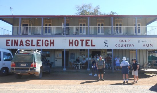
Einasleigh Hotel
A short distance from Einasleigh is Copperfield Gorge.
Copperfield Gorge at Einasleigh
It is hard to imagine what it must be like in the wet season up here.  This whole gorge is covered in raging floodwater.  Large depressions have formed where boulders have been rolling around gouging into the rock making mini waterholes.
Round depressions at Copperfield Gorge
Now we suppose you are wondering how we are going to get back to Mount Surprise now that the train has deserted us.  Well we have that covered – a mini bus is picking us up from Einasleigh and taking us back to the caravan park.  Along the way we stop for an afternoon tea.  The driver boils the billy over an open campfire and he has some home-made biscuits and slice …. Yummm!
Boiling the Billy
We also stop at Jardine Waterhole which is named after the Jardine Brothers who stopped to water their cattle on the long drove north to their father’s property at Somerset (the top of Cape York Peninsula).  Here our driver shows us some ‘Nardoo’ -  a plant that grows in waterholes and billabongs and is/was used as a food source by the aborigines.
Our driver showing us the Nardoo Plant
The ‘Nardoo’ needs to be ground into a paste before it is eaten otherwise it can be poisonous.  It is this plant that is thought to have contributed to the deaths of the Burke and Wills exploration party because they did not prepare it properly as shown to them by the aboriginals.  We return back to the campground in time for some wood fired pizzas for dinner.  A great ending to a novel day!
We’re packed up and on our way again – heading west through the Gulf Savannah country.  We stop at Croydon to refuel and have a wander around the old town.  With the discovery of gold in 1885 Croydon became a rich, booming, gold mining centre.  The town still calmly sits on top of deep untapped gold reserves and the historic Gulflander Train travels to Croydon from Normanton once a week.  There are many old buildings here that were built between 1887 and 1897 and one can wander through them.  We stop for a look at the Court House
Croydon Court House
and the Town Hall with its unique clock tower.
Croydon Town Hall
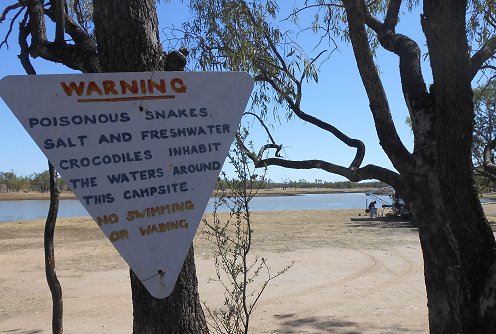
After a good look around town we continued west and free camped for the night  with a herd of cattle beside a waterhole.  The next day we continued on and thirty kilometres east of Normanton pulled into Leichardt Lagoon Camping Park.  This sign in the campground certainly pulls no punches
 
but Wok hasn’t seen the sign yet and thinks he has found the ideal spot.
Camping spot at Leichardt Lagoon
That night we headed up to the station homestead for a three course dinner (vegetable soup, corned meat and vegetables, rhubarb pie and icecream) and some live entertainment.  Part of the live entertainment turned out to be Ken our next door neighbour at the campground who can play the didgeridoo.
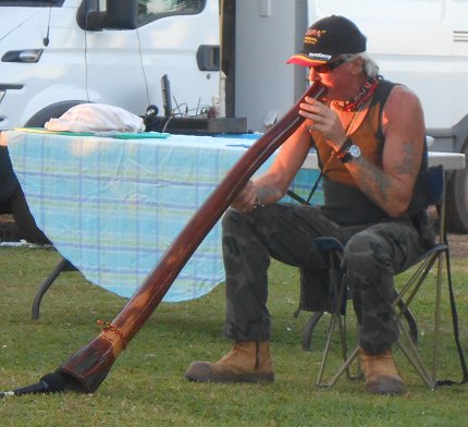
Ken plays the didgeridoo at the homestead cookout
It was a good night and all for the princely sum of $5 each – really good value for money.  The next day we relaxed and went fishing in the Norman River not far from the campground.  We caught no fish but that may have been the fault of the large saltwater crocodile that was patrolling up and down on the far side of the river.  That night as the sun set, Ken sat beside the lagoon and played some more ‘didg’ music.  If ever there was an ideal place to hear the didgeridoo then we think that this fit the bill perfectly.  It was a magical evening!

In the morning we broke camp and headed into Normanton.  Originally established on the Norman River by William Landsborough as the port for the Croydon gold rush, Normanton is now the major service centre in the Gulf Savannah.  It’s not a large town but does boast three pubs – one of which is painted an eye catching purple.  And what would you call a pub that is painted purple?  Why the Purple Pub of course!  We Australians are an imaginative lot when it comes to naming things! 
The Purple Pub at Normanton
The old general merchants’ building has been restored and now houses the Information Centre, library and museum.
Burns, Philp & Co Ltd. - General Merchants from late 1800's
Whenever people have talked to us about Normanton – the one thing they all mention is the statue of the huge crocodile in the main street.  Yes – there are saltwater crocodiles in the river but that is no different to many towns and rivers in the top end.  So when we did spot the huge croc statue in the park beside the council chambers we just had to stop and have a look.  The sign beside the croc explains the reason for it being here.
 
Oh my God!  Just standing near the replica sends shivers up our spine!
The replica of Krys the Croc holds no fear for this youngster
Although crocs of this size haven’t been seen in decades there still could be some monsters lurking in remote areas.  We will be quite happy for them to stay right where they are!
We travel 80 kilometres north to the mouth of the Norman River.  Here lies Karumba, the centre of the Gulf’s prawning and barramundi industries.  The wetlands here extend for 30 kilometres inland and are the home of saltwater crocodiles, pelicans, brolgas, black swans and many bird species.  We have seen pairs of brolgas before as we have travelled but as we near Karumba there are vast flocks of brolgas in the grasslands beside the road.  We take a drive around Karumba to check out the facilities and then head five kilometres north to Karumba Point and book into Sunset Point Caravan Park for a few days.  Karumba and Karumba Point are popular destinations for fisher people and many travellers come for the winter.  This is one of those places that it is wise to book ahead as there are no free camps here.  We managed to get a site for three days between two long term bookings by phoning over a week ago.  We figure that will give us enough time to check out the place to see if it may be somewhere we might like to come back to and spend more time at.  Opposite the caravan park is the boat ramp and the car park is full with cars and boat trailers.  At the boat ramp it is standing room only as fishermen return with their boats and wait while their fishing buddies jostle for a place on the boat ramp with their cars and trailers.
Standing Room only on the Karumba Point boat ramp
North along the beach more people are spread out trying their luck at fishing from the shore.
Fishermen at Karumba Point
We chat to some of the regular winter fishermen in the caravan park and they are all disappointed by the number of fish they are catching.  Although they are catching some species of fish, the barramundi are elusive.  One doesn’t have to be a genius to work out why the fish catches are down.  Trawler after trawler chug in and out the river mouth and a multitude of small boats head off each day.  Could it perhaps be a simple case of too many fishermen and not enough fish ....?    Over the next couple of days we tried our hand at beach fishing but didn’t even get a bite.  However, we did get stalked by a stork that was keen to see if we had caught anything each time we pulled our lines in
I'm just waiting here to see what you might catch ....
and we were entertained by an adult brolga trying to show a juvenile brolga the fine art of fishing.  At least the brolga was catching something even if it was minuscule.
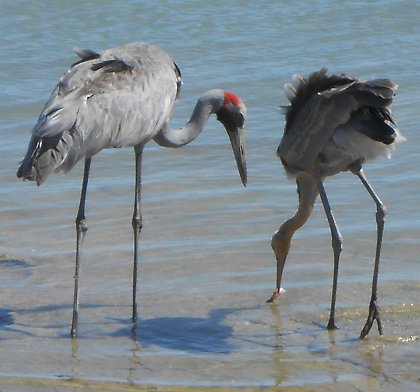
Hey Mum - Are you sure we really like to eat these things?

 Ahh Karumba!  It could be a lovely place if it weren’t for all those fishermen....