Friday, January 2, 2015

RYLSTONE and the CAPERTEE VALLEY

10th December, 2014

We’re back on the highway again and at Goulburn stop for lunch beside the Big Merino
The Big Merino - Goulburn
It doesn’t take a genius to work out what the main type of farm activity used to be in this region.  Today, along with the sheep, many farms have a diverse range of stock and crops.  It’s here we leave the mad Melbourne to Sydney freeway behind and travel the less frequented (and mountainous) road north to Lithgow west of the Great Dividing Range.  We free camp overnight beside the Abercrombie River in the National Park before continuing north.  At midday a sign entices us to detour to a lookout over the Capertee Valley.  We figure it will be a good place to stop for lunch and take in the view.  Unbeknowns to us the parking area at the lookout is the size of a postage stamp with no thought given about what to do about crazy caravanners who ‘heaven forbid’ may need to be able to turn around to get back out again.  Wok parks beside a barrier and we survey the situation.  We have two options ; reverse back down the 500 metre long steep access road that we took to get up to the lookout ; or wait for the family in the only other car at the lookout to leave and try and jiggle back and forth until we can turn around to get out.  While we ponder on what way is best we figure we may as well read the information board and take in the view.
Capertee Valley
We’ve always thought that the Capertee Valley was a picturesque place but someone has actually thought it necessary to compare it in width to the Grand Canyon.  Honestly – why bother?  
It’s special in its own unique way as is the Grand Canyon.

Ahh!  The other family has hopped in their car and left the lookout.  Wok decides that with a bit of help from Robyn standing in the middle of the road with a walkie talkie and guiding him backwards and forwards, he should be able to turn around.  After about fifteen minutes of precision maneuvering Mitzi and the Van are turned around and facing the exit.  We beat a hasty retreat down the access road before any other vehicle turned up and find a much more convenient spot to park and have some lunch.  By mid afternoon we are pulling into the small caravan park at Rylstone.  The facilities are basic (but clean) and with only two other campers on site we virtually have the place to ourselves.  The reason we have come to Rylstone is to do a bit of family research and spend some time exploring the area.  Robyn’s great Grandfather came from Wales to Australia in 1852 and settled on the land near Rylstone after spending a couple of years as a police constable in the town and then trying his luck on the nearby goldfields.  The next day we took a walk around town – stopping to read the plaques outside the historical colonial buildings.  The following photos are just a selection from the many that we took :-
Police Residence
James Nash House
Slab cottage
St James Church of England
After a couple of days relaxing we took a drive to the east of Rylstone, stopping for a look at Dunn’s Swamp.
Dunn's Swamp
The name does not do this beautiful lake justice.  Probably before the weir was built this may have been nothing more than a marshy swamp but now it is a lovely waterway.  There is quite a substantial campground beside the water and we watched as two fishermen launched their boat and disappeared out of sight upstream.  Lots of water birds were also enjoying themselves along the shore.  The waterway is part of Wollemi National Park which is known for its fascinating rock formations – such as these ‘pagodas’.
Pagoda rock formations - Wollemi National Park

Further east of Dunn’s Swamp we descended into the Capertee Valley and at Glen Alice stopped for a walk around the cemetery and took a photo of the Presbyterian Church built in 1874.
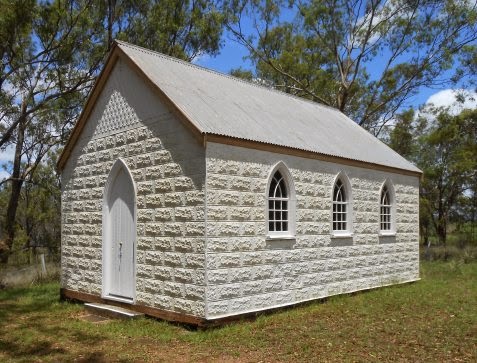
Glen Alice church 1874
The church was originally of timber slab construction which was later clad in pressed metal.  Although small, the church is still used by the Anglican and Uniting church on alternate Sundays.  We continued on through the valley stopping at Glen Davis which along with Glen Alice were the main sheep stations in the valley.  Then it was time to take a circular route out of the valley exiting near the lookout and finally arriving back at Rylstone late in the afternoon.
The area around Rylstone still has many sheep farms, but over the past couple of decades a thriving vineyard industry has grown up around the towns of Mudgee, Rylestone and Kandos.  Of course in the middle part of the nineteenth century the area was a hive of activity with gold having been discovered.  A drive to the west takes us to the town of Gulgong with its narrow main street and heritage listed buildings.
Main Street of Gulgong
We decided that a pub lunch would be in order and the Commercial Hotel looked like a good choice.
Commercial Hotel Gulgong (on left) - Real Estate Office (on corner)
As we walked through the front door Wok noticed that the proprietor’s surname was ‘Honeysett’ and as Robyn’s grandmother was a ‘Honeysett’ we wondered if there was a family connection.  To our surprise the lady behind the bar who took our lunch order (Kim) said she had married an Andrew Honeysett and while we were having lunch she came and sat with us and pulled out a large file which was full of family history records.  After checking a few ancestors in the family tree we confirmed that Andrew was indeed a distant relative and we had a lovely chat with Kim and promised to email her some of the relevant stories and information we had on the ‘Honeysett’ side of the family.
While staying at Rylstone we couldn’t miss the chance to visit the nearby town of Kandos.  Established in 1915 the town was purpose built for employees of the Kandos Lime and Cement Company’s quarry.  The works site and the town is situated on part of Robyn’s great Grandfather’s (John Lloyd) property which was called ‘Ferndale’.  After John Lloyd died in 1910 the land for the town and works site was separated from the farm and sold to the cement company.  The cement works operated for nearly 100 years and has only recently closed a few years ago.  We visit the museum which is operated by volunteers and undergoing renovations to the building and its displays.  The railway was an important part in the development of this area and goods and passenger trains made frequent runs to Sydney.  Today the track is only open to Kandos and special event trains run infrequently – eg. maybe once or twice a year.  We stop in at the Kandos Railway Station which has been converted into a restaurant/gift/coffee/ice cream parlour for a late lunch. 
Whistle Stop Café in old railway station at Kandos

The ‘Whistle Stop Café’ is also run by another pair of distant ‘Honeysett’ relatives – David and Sue Honeysett.  David was surprised to learn that he was distantly related to Andrew Honeysett of Gulgong as he had always believed they were not related.  Should make for some interesting conversation when they meet up again.
After a week of exploring the countryside and ‘digging up’ lost relatives we hitched up the van and headed north again.  Christmas was not far off and we had arranged to meet up with Wok’s sister Gwen and her husband Roger at Scone for one night.  They were headed off to Moree to spend Christmas with their daughter while we were heading off in another direction to spend Christmas with our daughter.  We had a great meet up in Scone and even managed to win a leg of ham in a raffle.  We’ll put it in the frig and take it with us back to the sunshine coast for Christmas.  We don’t often see too many caravans decorated up for Christmas but this one at Scone Caravan Park was worthy of a photo in the blog.
Christmas Lights at Scone Caravan Park
The following day we waved goodbye to Roger and Gwen at the turnoff to Quirindi and that afternoon pulled into a free camp at the ‘Mother of Ducks Lagoon’ in Guyra.
Free camp at Mother of Ducks Lagoon in Guyra
It’s a great place for an overnight stop as it is away from the noisy highway and has a nice outlook over the pond (which is part of the water catchment area) and across the golf course.  Wok goes for a walk around the pond and finds a patch of mushrooms growing wild.
Looks like steak with mushroom sauce for dinner
We move on the next morning and arrive at Tina and Paul’s home on the Sunshine Coast a few days before Christmas. With our son Trent flying in from Newcastle to join us it will be the first time in two years that the family has all been together.  We wish all our family and friends a very merry Christmas and a safe and happy New Year.  We’ll catch up with you all in 2015 …

Saturday, December 6, 2014

GUNDAGAI

2nd December, 2014

The further north we go the hotter it gets so we detour east to take the road less travelled.  The Snowy Way climbs up into the western foothills of the Great Dividing Range and with altitude comes cooler temperatures – at least that is what we are hoping.  We stop for an overnight freecamp on the New South Wales side of the Murray River five kilometres from Corryong and the following day drive up into the mountains.  Near Tumbarumba (at an altitude of 750 metres) we pull into a freecamp area at Burra Creek beside the Hume and Hovell walking track. 
The temperature is a much more reasonable 24 degrees – better than the 34 degrees of the past few days.  We find a spot beside the creek and soon have the van set up on site.
Campsite beside Burra Creek
While waiting for lunch to miraculously appear from the depths of the van Wok keeps watch for any movement in the creek.
Wok waiting for a fish to swim by
With no fish making their presence known we go for a walk along the track beside the creek.  Explorers Hume and Hovell passed this way on their journey south and on the 400 kilometre long stretch between Yass and Albury there are eleven trackheads where hikers can enter or exit.  We are camped at Henry Angel Trackhead – named after a convict who was assigned to the explorers.  In the late 1800’s and early 1900’s the creek was also the scene for gold mining and the landscape became scarred with tailings.  Evidence of the mining can still be seen beside the track and along the creek bank.  We also kept finding wombat holes all over the place.  Some had not been used for quite some time but others were obviously still occupied.
Wombat holes at Burra Creek
 
We kept an eye out that night in case a wombat came waddling by but the only wombat we saw was one that was taking a nap in the middle of the road the next day.  We continued north along the Snowy Way to Tumut and then followed the Murrumbidgee River to Gundagai where we decided to stop for a few days and take in the sights.
Gundagai - caravan park on river between the two bridges (left hand corner of photo)
We had just set up on site in the River Caravan Park when a line of thunder storms rolled through.  Luckily for us the main part of the damaging winds and hail passed to the west and east of Gundagai.  When the storm had passed the river looked rather eerie as mist rose above the water.
Mist rising from the Murrumbidgee River at Gundagai
Most Australians are familiar with the iconic country ballad ‘Road to Gundagai’ and the ‘Dog on the Tuckerbox’ – so our first port of call was to visit the memorial to the ‘Dog on the Tuckerbox’ five miles from Gundagai.
At least now there is an information board beside the memorial telling visitors the story behind the sculpture.
On our way back into town we take a detour to the cemetery to visit the resting place of bushranger Andrew George Scott – better known as Captain Moonlite.
Unlike most bushrangers Andrew Scott was well educated and even trained as an engineer before travelling with his parents and brother to New Zealand.  After serving in the military in New Zealand he made his way to Australia where he trained as a lay preacher.  It is a mystery as to why he committed his first bank robbery but by the time his bushranging days ended in 1879 the legend of ‘Captain Moonlite’ was forever written in Australian colonial history.
We stop at the Information Centre in Gundagai to have a look at something we had been told about.  Displayed in a back room is a marble masterpiece made by Rusconi (the sculptor of the ‘Dog on the Tuckerbox’)
Rusconi's Marble Masterpiece
Rusconi spent over 28 years painstakingly making this over a metre tall model with small pieces of coloured marble obtained from different areas of Australia.  It is a beautiful piece of workmanship and something you would expect to see in a major gallery.
In the park beside the Information Centre is another sculpture that once stood five miles from Gundagai near the ‘Dog on the Tuckerbox’
Dad, Dave, Mum and Mabel (all decked out for Christmas)
Before television - (Yes there was a time before TV) – we remember listening to ‘Dad and Dave’ on the radio.  Our guess is that 'our generation' will be the last to really know what it was like to gather around the radio each evening to listen to favourite radio serials.
We take a walk along the main street in Gundagai and pass a couple of hotels dating back to the late eighteen hundreds.
 
At the far end of the main street and just around the corner is the local museum housed in the old Bank of New South Wales building.
Gundagai Museum
We go in for a quick look around only to discover that we have entered the Tardis of museums.  Everything and anything was on display and more importantly there were information notes and boards explaining what the article was.  Oodles of photos of the town, the farms and the people adorned the walls.  A whole section is devoted to the devastating flood of 1852 when the fledgling town was completely destroyed and 89 people died – many survivors owing their lives to four aboriginals who rescued people from roofs and trees in bark canoes.  There was even a bark slab dunny on display in the backyard.
Privacy wasn't an issue - just pull the hessian bag across for a screen
Once upon a time there were two wooden trestle bridges across the river and floodplain – one for the railway and one for vehicular traffic.  In 1985 a new bridge was opened which diverted the highway to the west and around the town.  The two wooden bridges have now fallen into disrepair and are closed.
The old railway bridge at Gundagai
The old vehicular bridge at Gundagai has seen better days
Since 1979 the town has been trying to raise money to save the historical bridges but sadly the finances needed may be too astronomical for this small community.  One day the bridges may disappear and part of Gundagai’s history will be gone forever – but for now we can appreciate their special place in the building of this country town.

Sunday, November 30, 2014

GLENROWAN and MOUNT BUFFALO

27th November, 2014

Well there we were, hurtling north up the Hume Freeway, when a road sign caught our eye.
A quick decision was made and we took the next exit and checked into Glenrowan Tourist Park – a sleepy little caravan park set in bushland.
Camped at Glenrowan Tourist Park
Over the next couple of days we explored the area and were entertained by the kangaroos and rabbits foraging in the nearby paddocks each afternoon.
There is no getting away from the legend of Ned Kelly in Glenrowan as this was the place where he was captured.  Even if you knew nothing about Ned the humongous statue of him in the main street should be a dead give-away.
Can't miss this in the main street of Glenrowan
Glenrowan is a small country town with tourism its main source of revenue.  Anything and everything ‘Ned’ can be obtained here and a museum depicts the siege at Glenrowan where Ned was captured.  A reconstruction of Ned’s family home is also on display.
Replica of Ned Kelly's family home
The following bit of information is a snapshot of the Ned Kelly legend :-
Edward "Ned" Kelly (December 1854 – 11 November 1880) was an Australian bushranger of Irish descent.  His legacy is controversial; some consider him to be a murderous villain while others view him as a folk hero and Australia's equivalent of Robin Hood.

Ned Kelly was born in Australia in the town of Beveridge in the state of Victoria to an Irish convict father and an Irish-Australian mother.  His father died after a six-month stint in prison for unlawful possession of a bullock hide when Ned was twelve.  Following an incident at his family's home in 1878, police parties searched for Ned in the bush.  After he, his brother Dan and two colleagues killed three policemen, the colonial government proclaimed Kelly and his gang ‘wanted outlaws’.

A final violent confrontation with police took place at Glenrowan on 28 June 1880.  Ned, dressed in homemade plate metal armour and a helmet, was captured and sent to jail.  He was convicted of three counts of willful murder and hanged at Old Melbourne Gaol in November 1880.  His daring and notoriety made him an iconic figure in Australian history, folklore, literature, art and film.

For those of you who may want to know more about Ned Kelly just go to the following website :-
At the siege site information boards describe the events that took place and we wander along the trail leading from the site of the Inn to where Ned was finally captured.
Site of the Glenrowan Inn where the siege took place - Mount Glenrowan in background
1880 photograph of burnt out remains of Glenrowan Inn
Just loved this 'log' Ned Kelly depicting the place where he was captured
Photograph of Ned Kelly taken one day before he was hanged
The following day we took a drive to Mount Buffalo – stopping off at Greta Cemetery where Ned Kelly (minus his head) and his mother lie in unmarked graves.  Ned was only recently interred in the cemetery and a headstone has been erected by the Kelly descendants in memory of Ned, his mother and other family members.
We can see Mount Buffalo from the caravan park but it is a good couple of hours drive away.
Mount Buffalo
Along the way we notice that many of the farms have kilns – not in use.  When we reached Myrtleford we stopped at a picnic area where one of these kilns was on display and found out that they were ‘Tobacco Kilns’.
Tobacco Kiln at Myrtleford
There must have been a lot of tobacco being grown here in the 1900’s as every farm we passed seemed to have anywhere up to several kilns on their property.  Obviously the bottom must have fallen out of the tobacco market as we did not see one crop of tobacco now being grown.  Just past Myrtleford we turn onto the road leading to Mount Buffalo National Park.
Driving up Mount Buffalo
The road winds back and forth up the cliff faces for over twenty kilometres with rugged granite outcrops dominating the landscape.  As we traverse the terrain across the top we can see the feature known as the ‘Horn’
The Horn (Mount Buffalo)
and as we get closer we can see people standing at the railing on the top.
The Horn (Mount Buffalo)
At the car park on the western side of Mount Buffalo an old shelter still stands
Wok at road's end - Mount Buffalo
and a panoramic vista opens up.
View from the shelter - Mount Buffalo
View the other way at the shelter - Mount Buffalo
It always amazes us to see where some trees manage to find a foothold and survive the elements.
Just love this tree growing between the granite boulders
On the way back down the mountain the stark white skeletons of trees caught in a devastating bushfire a decade ago catch our eye.
Bushfire devastated trees on Mount Buffalo
We got back just in time for happy hour at the caravan park with the rabbits and kangaroos.  
Its stone fruit harvest time with lots of fruit being sold at the farm gate – so we couldn’t drive past without taking full advantage of cheap prices and tasty produce.

Wok is all set - computer to play with - apricots and cherries to munch on ..
Hmmm  -  wonder how many cherries one has to eat before a falling into a ‘cherry coma’ ... ?