Tuesday, November 25, 2014

MORNINGTON PENINSULA

13th November, 2014

After a detour into the northern suburbs of Melbourne to check out a new Crusader caravan for Roger and Gwen (Wok’s sister and brother-in-law) we headed south to the Mornington Peninsula and checked into the Stony Point Caravan Park on Westernport Bay.  The caravan park is situated right beside HMAS Cerberus naval base and is a stepping off point for a ferry to French Island and Phillip Island.
Stony Point Jetty
Besides the Stony Point Caravan Park there are only a couple of houses, a small shop, dockside offices for the Westernport Marine Authority and a train station where one can take a two carriage train to Frankston and then hop on a train to Melbourne.  It’s a great place for some quiet camping with the occasional day trip to explore the peninsula.  This is also a popular spot for local fishermen to launch their boats and after setting up the van on site we take a walk to the foreshore to see what type of fish the returning boats had brought back.  We weren’t the only ones interested in the catch and the fish cleaning tables were staked out by a bevy of pushy pelicans.
Pelicans at the fish cleaning table Stony Point
Two fishermen had just tipped their esky full of red schnapper onto the table and we chatted to them as they cleaned their catch.
Fisherman at Stony Point with his catch of red schnapper
All the while the ever vigilant pelicans and seagulls kept a watchful eye on the proceedings and were quick to snaffle up any discarded morsels.
Aww ... come on ... I'm being really really good ... !
Our first excursion is south along the eastern coast of the peninsula, popping in and out of the small seaside villages until we get to the most southern point at Cape Schanck.
Cape Schanck Lighthouse
Then we cross over the peninsula to the western side and Port Phillip Bay and follow the coast north checking out the seaside holiday villages of Sorrento, Rosebud and Dromana before climbing up to the lookouts at Arthurs Seat.  The views are fantastic with the peninsula spread out on both sides and disappearing into the haze.
View of Mornington Peninsula towards Point Nepean from Arthurs Seat
And we did actually find Arthurs Seat on top of Arthurs Seat.
Robyn takes it easy at Arthurs Seat
It was late afternoon by the time we followed the ridge road through Red Hill and back to Stony Point.  Our next excursion was to the furthest point on the Peninsula – Point Nepean National Park.  It was a lovely sunny day and the colour of the water was turquoise and blue – simply enchanting.  Point Nepean National Park is not fully accessible for private vehicles so we parked Mitzi and caught the shuttle bus into the park.  One of the first stops along the way is Cheviot Beach where a memorial to Prime Minister Harold Holt is located.
Cheviot Beach
We remember at the time the media frenzy surrounding the disappearance of Australia’s Prime Minister and the many rumours – from him being taken by a Great White Shark to being kidnapped by scuba divers from a Russian submarine.  The reality is that he more than likely was caught in an undertow and simply drowned but one can’t let the truth get in the way of a good story.  With no witnesses and no body the disappearance will always be a mystery and this secluded beach is now part of Australian history.

The shuttle bus winds its way along the narrow road out along the peninsula with Bass Strait on one side and Port Phillip on the other.
View back along the peninsula - Port Phillip Bay on the left and Bass Strait on the right.
The bus drops us off at the furthest point on the peninsula – Point Nepean.  There is a wonderful view of the entrance to Port Phillip from here.
View from Point Nepean across the entrance to Port Phillip Bay
The entrance to Port Phillip was the most heavily forted port of the British Empire with Fort Nepean standing guard over Bass Strait and the entrance to the bay.  Built in the 1870’s the fort was manned through both World Wars.
Wok makes his way towards the tunnels
We explore the tunnels
Wandering through the maze of tunnels
and fortifications and read the information boards which give us an insight into the history and life of the military personnel stationed here.


After wandering through the maze of tunnels and gun emplacements we eventually make our way back to the bus stop.  Point Nepean National Park was also home to a Quarantine Station which was established in 1852 and operated until 1952 when the buildings became home to the Officer Cadet School until 1985.  From 1985 to 1998 the buildings were used as a School for Army Health.  The site is now looked after by the National Parks and there are over 50 heritage listed buildings.
Avenue of trees at the Quarantine Station
We stroll around the site and through some of the buildings. 
Heat Oven for processing luggage of Quarantined passengers
There are five large buildings that were used as hospitals for sick passengers off the boats that entered Port Phillip.
One of the hospital buildings at the Quarantine Station
With many immigrants pouring into the colony in the second half of the 1800’s the outbreak of diseases such as typhus was a constant threat.  The tragic stories of those who were put into quarantine and those who died and were buried here are heart rending.  Some of Robyn’s ancestors may have passed through the Quarantine Station on their way to the Victorian goldfields in the 1850’s.  We wondered what they would have thought of this strange country so different to their home in Britain.
After leaving the National Park we followed the coast around Port Phillip Bay.  In the distance across the water we could just make out the outline of Melbourne’s high rise buildings in the haze.
View of Melbourne (in the haze) from Mornington Peninsula
All along the beaches on this side of the peninsula are colourful bathing sheds – a reminder of a bygone era.
Bathing sheds on Mornington Peninsula
Our time on the peninsula is nearly over and we’ve enjoyed exploring the many roads and by-ways that criss-cross its length.  Before we leave there was one last stop to make – sunset over the water at Portsea. 
Sunset at Portsea
Breathtaking ….. 

Monday, November 10, 2014

PHILLIP ISLAND

9th November, 2014

It’s not a long drive to switch camps today – just over 100 kilometres.  At San Remo we stop for a fish and chip lunch beside the bridge crossing from the mainland to Phillip Island.  The pelicans here also get a midday meal and there were coaches full of tourists (mainly asian) lined up along the foreshore eager to get that once in a lifetime photo.
Pelican Feeding time at San Remo
After lunch we drove over the bridge and along the road to Cowes (the main town on Phillip Island) passed the remains of chicory kilns – a thriving industry on the island in the late eighteen hundreds and early nineteen hundreds.
Chicory Kiln on Phillip Island
We check into Cowes Caravan Park which is situated on the foreshore of Western Port bay and that night while we are having dinner watch a family of rabbits munch their way through the grass around the van.  In the morning we hope into Mitzi and take a drive to The Nobbies at the western end of the island. 
The Nobbies on Phillip Island
A nature reserve has been established here and board walks guide visitors over nesting areas for marine birds to viewing platforms.
Boardwalks along the cliffs at The Nobbies
There were lots of seagulls diligently guarding nests
Seagulls nesting at The Nobbies
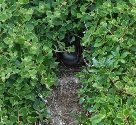
as well as burrows where penguin chicks were having a nap while waiting the return of their parents.
Peek-a-book penguin chick in its burrow
We can just make out the shape of Pyramid Rock in the distance so decide to take a walk along the coastal track for a closer look.
Pyramid Rock on Phillip Island
There are signs along the boardwalks giving information on the local wildlife and we were surprised to see this copperhead snake trying to sun itself under a “Stay on the Path’ sign.
Copperhead Snake under sign on coastal walk near Pyramid Rock
As copperhead snakes are venomous we left it up to its own devices and continued on our merry way.  The main tourist attraction on the island is the nightly penguin parade when the adult penguins return to their burrows to feed the chicks.
Penguin Parade
The viewing of the penguins is strictly supervised and tracks are kept clear to allow the penguins access to their burrows without being harassed by over enthusiastic humans.The following day we drive to Cape Woolamai and take a walk along the beach.
Cape Woolamai
Then it was time to undo all the good those nice long walks had done – a well deserved stop at the chocolate factory where this sign only confirmed our rationale for being there.
We wandered through the museum where the chocolate sculptures were truly remarkable.
Chocolate sculpture of 'David' ... even the leaf is chocolate
And this model train chocolate town would satisfy two male passions.  Eating chocolate and playing with trains ...
Chocolate model train village - even the streets are chocolate !
We had a great time trying to win chocolate balls on the fun parlour games in the museum and making chocolate shapes with the aid of a specially designed machine.  We then got to eat our masterpieces .... yummm!   And sitting amongst giant chocolate bars is what dreams are made of.
No Wok!  You can't stay there ...
There are lots of conservation efforts being undertaken on Phillip Island – from marine animals, to seabirds, to koalas.  All worthy causes which have been managed well on the island for a number of years.  We’ve enjoyed our stay here and tomorrow we will cross the bridge and head back to the mainland.  There is one last piece of information that we gleaned from the chocolate factory which we believe bears some consideration and that is
 
Yep ... sounds just about right to us !

Saturday, November 8, 2014

WILSON'S PROMONTORY, CAPE LIPTRAP and WARATAH BAY

5th November, 2014

Time to be on the road again and we wind our way down the hills and valleys to Moe where a quick stop to restock the larder is accomplished.  Then we head south following ridges and green valleys until we near the coast.  We check into Waratah Bay Caravan Park and get set up on a site overlooking a beach that wraps around the bay.
Steps leading down to the beach from our campsite at Waratah Bay
To our left we can see Wilson’s Promontory and to the right is Cape Liptrap.  Just over the horizon, directly in front of us, lies Tasmania.  In the morning we hop in Mitzi and drive around the bay to Wilson’s Promontory National Park – the furthest point south on the Australian mainland.  Tidal River campground is the end of the road for vehicular travel so we park the car and do some walking.  The scenery is spectacularly rugged
Tidal River at Wilson's Promontory
with the river emptying out into the bay.
The entrance to Tidal River at Wilson's Promontory
The southern end of the beach is tucked in under a large granite outcrop.
The southern point at Tidal River
The ‘Prom’ is a hiker’s paradise with tracks ranging from short strolls to strenuous overnight rambles.  We definitely fall into the ‘short stroll’ category.  We take a walk to ‘Squeaky Beach’ being careful to take notice of the warning signs.
The beach was so named because the rounded quartz sand ‘squeaks’ when you walk on it.
Squeaky Beach
The rock formations at the north end of the beach are quite striking

Wok takes it easy at Squeaky Beach
with a maze of passages that are fun to explore.
No Wok - We don't believe you are stuck!
The park boasts an abundance of native animals and although we did not see an abundance, we did see one emu, one small kangaroo (maybe a wallaby) and one echidna.  There are road signs advising one to take care when driving and one sign caught our interest.
We’re not going to say what sort of animal this is – thought our overseas friends needed to have a guess.  Needless to say it isn’t one of the critters we did see.
Wow – what a change in the weather.  The next day we have jumped in temperature from a pleasant 22 degrees to very hot 32 degrees.  We aren’t daunted though!  We don our sunscreen and hats and head off to do some more sight-seeing.  On the opposite side of the bay is Cape Liptrap and we follow the lighthouse track to take in some spectacular views over Bass Strait.
Cape Liptrap lighthouse
The Cape offers a panoramic view of Wilson’s Promontory stretching south towards Tasmania.
Wilson's Promontory in the haze
We follow the dirt track down to the small hamlet of South Walkerville.  In 1875 lime was discovered in the cliffs here and in 1878 the first lime kiln was built.  At its peak there were five kilns operating with the quick lime being transported to Melbourne by ship.  The last kiln ceased operation in 1926.  We meander along Limeburners Walk where the remains of a couple of the kilns can be seen.
Remains of lime kilns at Walkerville
We wander along an overgrown track just above water level to get a better look at the bottom of the kiln where the men would rake out the lime powder for bagging and stacking.
Wok points to where the quick lime was raked out from under the kiln
We were making our way back along the track when we were surprised to see another trekker making their way toward us.
Out of the way!  Echidna coming through ...
Mr/Mrs Echidna seemed oblivious to our nearness and slowly made its way up the track checking under rocks and twigs for a likely meal.
Checking out the rock for some tasty delicacies ...
The echidna eventually ambled off into the undergrowth leaving us alone on the track once more.  We both looked at each other - a chance encounter – one to remember!
Back at camp and another hot day - time to relax and take in the natural beauty around us.  What better way to finish up our stay here.  Just strolling along a deserted beach … pure magic !
 

A PRISON then MALLACOOTA to WALHALLA

27th October, 2014

We’re finally on our way and a toss of the coin has us heading south into the alpine region.  The weather was fine as we were packing up but a southerly change has arrived and the wind is picking up.  We stop outside a Woolworths in Cooma for some grocery shopping and while putting said items away in the van notice that we have pulled up beside a museum – and not just any old museum.  This is a Corrective Services Museum … ??
Parked outside the Corrective Services Museum in Cooma
Of course, curiosity got the better of us and we just had to investigate.  As we walked along the street side of the museum there was a mural with information panels telling us that the museum was a history of the Corrective Services beginning in 1788 when the First Fleet arrived.  As soon as the first convict set foot on Australian soil the soldiers in charge became the fledgling beginnings of the Corrective Services.  We rounded the corner of the museum and to our surprise found that the museum was attached to a fully operational prison.
Cooma Prison Entrance
While we were admiring the architecture of the prison a guard approached us and asked if we wished to see inside the museum.  When we told him ‘yes’ he said that normally the museum was closed on Mondays (and yes – it was Monday) but he had just had a pre-arranged bus load of tourists go through and he would keep the museum open for another half hour for us to have a look through.  What a nice guy!  The museum occupied part of one of the original prison buildings and although small was crammed with information and displays.  At the rear of the building a small workshop was in operation with trustees from the prison making craft items to sell in the shop attached to the museum.  The guard told us that Cooma prison is one of the oldest operating prisons in New South Wales and 167 inmates were incarcerated behind its walls.  The prison was certainly a surprise to stumble upon.  Not something one would expect to find only a stone’s throw from the main shopping precinct.
Back on the road again – well sort of.  The wind was blowing us all over the road and it was becoming quite hairy.  Forty kilometres further on we pulled into Nimmitabel and took refuge behind a hedge in the little shire operated caravan park.  It was early afternoon but we decided to play safe and stay put for the night.  There were only two permanent caravans other than us in the park and a sign said that the caretaker would come around to collect fees at the end of the day.  The wind blew and blew and blew – it must have blown the caretaker away as we never saw hide nor hair of him before we left the next day.  At least the wild weather had moved on and the drive over the mountains and down to the coast was pleasant and scenic.  By midday we were checking into the foreshore caravan park at Mallacoota – in the north eastern corner of Victoria. 
Wok is pumping up the tyres on our bikes - ready to ride in Mallacoota
Over the next four days we enjoyed the sunny weather and did some sight-seeing, walking, bike riding and just lazed around.
Wok checks out the boats while the pelicans take a break along the Mallacoota foreshore
Looking out over the estuary at Mallacoota
Pied Cormorants at Mallacoota
We’ve done it again!  The morning was fine while we were packing up but within half an hour of being on the road a change has occurred with wind and rain buffeting the car and van.  We pull over in a rest area and have an early lunch – hoping that the weather will improve.  After two hours there seems to be a break in the weather so we hit the road again.  The lull in the wind and rain only lasts a short while and we decide that enough is enough and pull into a little campground in Bruthen for the night.  By morning the worst is over and before we check out of the campground phone ahead to see if there is a site in the caravan park at Rawson.   We don’t normally have to do this but we have only just realized that it is the weekend before the Melbourne Cup and in Victoria this is an extra long weekend for some people with the public holiday for the Melbourne Cup being on the Tuesday.  We are in luck!  The Rawson Caravan Park was booked out but a camper has had enough of the wet weather and checked out early.  As we want to stay three nights they will hold the site for us.  We arrive at midday and are soon set up on site amidst the tall timber.
Our campsite among the trees in Rawson
Rawson was a purpose-built town to provide accommodation for workers on the Thomson Dam.  The workers have long since moved on but its setting amid the bush makes it a good base for bushwalking, four wheel driving, mountain biking and trout fishing.  The following morning we hop in Mitzi and take the short drive to Walhalla.  In 1862 gold was found in the valley and by 1880 a vibrant mining community was in full swing with a population of over 3,000 people.  There were 10 hotels, 7 churches, several dance halls, a hospital, a school with more than 500 students, sporting clubs and over 50 shops.  During the gold era over 70 tonnes of gold was removed from the valley.  In 1910 the railway finally arrived, but it was too late.  Gold yields were falling and the major mines had all closed by 1914.  Walhalla was then effectively abandoned as people moved away to find work elsewhere.  Most of the houses and buildings were pulled down and shipped to other towns while others were simply abandoned.  The structures that remained were mostly destroyed by fire and Walhalla was virtually a ghost town.  In the 1990’s following a renewed interest in Australia’s heritage many of the homes and shops began to be rebuilt and now boasts a permanent population of 20 residents. In 1998 Walhalla became the last town in Victoria to be connected to electricity. This once forgotten gold mining town is now a popular tourist destination. 
Walhalla
At the southern entrance to the town is the Walhalla Goldfields Railway – a narrow gauge train that winds its way down the gorge to the Thomson River.  The railway was never a success with the line closing in 1944 but it has now been reopened by enthusiasts who have lovingly restored this section of the line.  Along with the cemetery that clings to the side of the hill at a 45 degree angle are cottages built on narrow ledges cut into the steep hillsides.  On the hillside above the town lies the Long Tunnel Extended Gold Mine.  Over 13 tonnes of gold was removed from this mine making it one of the most successful in Victoria.  The mine has long since ceased operations but guided tours can be taken to relive what it was like for the miners of the day.  We stroll around the town enjoying a pleasant day and our step-back-in-time.
The Rotunda in Walhalla - Masonic Lodge on hill behind

The Mechanics Institute
The Post Office and Residence
The Fire Station is built over the creek
Vintage cars on a rally parked outside the Star Hotel
St Luke's Church perched on the hillside
It’s another day and we hop in Mitzi to take a drive to the Thomson Dam.  Work was commenced on the dam in the 1960’s with many of the workers coming from the Snow Mountains Hydro Scheme.  Completed in 1984, the dam is home to half of Melbourne’s drinking water.  At 165 metres high it is the biggest earth and rockfill dam in the southern hemisphere.  Photos do not do this dam any justice – there is no way to convey the massive rock wall that has been constructed to hold back the water.
The massive rock wall of Thomson Dam

On our way back to the campground we do a bit of off road sight-seeing winding our way through ancient Myrtle Beech forests
Driving in the national park near Mt Erica
before stopping to take a walk to Mushroom Rocks.
Mushroom Rocks
Back at camp we relax and listen to the sounds around us.  Children playing, families gathered around campfires, someone chopping wood for those campfires, the distant sound of a guitar – and in the background the myriad sounds of bird calls.
A holiday weekend in the Australian bush …… priceless !